 Brooke Larsen
This story is part of a series on Utah’s transbasin diversions, produced by The Salt Lake Tribune, KUER and KSL. It was reported in partnership with the Colorado River Collaborative, with support from The Water Desk at the University of Colorado, Boulder.
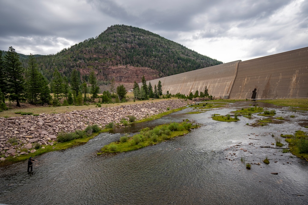
A massive concrete wall rises 200-feet above a trickling creek where Duchesne County’s tan plateaus transform into green forested slopes. Behind it, snowmelt from the Uinta Mountains pools into a dark blue reservoir, water lapping on red rock shores.
At just over 8,000 feet in elevation, the Upper Stillwater Dam marks the start of the Central Utah Project, which conveys water from the Colorado River Basin to the Great Basin where around 90% of Utahns live.
“It’s the crown jewel of the Central Utah Project,” Dylan Dastrup, Stillwater area manager with the Central Utah Water Conservancy District, said as he pointed to the grey wall. The district maintains and operates the project facilities, which are owned by the federal government.
From Upper Stillwater, a drop of water, which otherwise would flow to the Duchesne River, then the Green River before meeting the Colorado, begins a journey west. It does that thanks to decades of engineering and over 100 miles of tunnels, pipelines and diversions that carry the water to the state’s biggest cities. After a pit stop at Strawberry Reservoir, it cuts through the mountains and flows into pipelines that deliver water to farms, lawns and taps across the Wasatch Front.
Some of that water even makes it as far as the Salt Lake City International Airport.
(Christopher Cherrington | The Salt Lake Tribune)
“Utah’s economy, especially the Wasatch Front’s economy, would not be what it is without the Central Utah Project,” said Troy Ovard, area manager with the water district. “But I don’t think most people fully realize that.”
When Utahns hear “Colorado River,” they may picture rafts flowing down rapids near Moab or houseboats zooming across Lake Powell. The district wants to challenge that notion, though.
“You — living on the Wasatch Front — are the Colorado River,” Dastrup said. “When we conserve water in Salt Lake or in Lehi, that’s water that’s conserved in the Colorado River.”
In all, just over a quarter of the water used in Salt Lake, Utah and Wasatch counties comes from the Colorado River Basin, according to Utah State University.
“It’s a supplemental source,” said Jared Hansen, manager of the Central Utah Project. “It’s not all of anyone’s water, but we serve between 1.5 and 2 million people, depending on the year.”
In addition to the Central Utah Project, two other major transbasin diversions and a handful of small projects bring Colorado River water to the Great Basin.
The Provo River Water Users Association diverts water from the Duchesne River to the Provo River for farms in the Heber and Kamas areas and cities such as Sandy and Orem.
The Strawberry Valley Project, one of the oldest transbasin diversions in the West, brings water from the Strawberry Reservoir to farms and cities in Utah County. This project outdates the Central Utah Project and distributes water to users separately, but aspects of the two projects’ operations have become integrated at Strawberry Reservoir.
All the transbasin diversions combined diverted around 165,000 acre-feet of water in 2024 to the Great Basin, according to the Upper Colorado River Commission, making up around 15% of Utah’s total Colorado River consumptionthat year. The district anticipates diversions increasing over the next decade, though, as construction recently finished on infrastructure in Utah County.
Drought has plagued both the Great Basin and the Colorado River Basin, making every drop of water matter to Utah’s rapidly growing cities.
Meanwhile, the seven states that share the beleaguered Colorado River continue to fight over its shrinking supply of water. And if Utah has to cut its Colorado River use in the future, that could mean less water for the Wasatch Front.
“When you turn on your tap and the water’s there, it’s really easy to take that for granted,” said Brad Perkins, senior engineer with the district. “But the process and how far that water had to travel to get to your tap is really an incredible story.”
A journey through mountains
Before spring’s warmth melts snow in the Uintas, Dastrup makes sure Upper Stillwater Reservoir is nearly empty so the dam can capture as much runoff as possible. Rather than storing water long term, it acts as a massive diversion structure, capturing runoff and funneling to the Central Utah Project.
After leaving that reservoir, the diverted water flows into the Stillwater Tunnel, which is just big enough to fit a golf cart. That’s what Dastrup drove down the concrete tube in the fall of 2025 during an annual inspection for cracks and erosion, clogs in groundwater drains and changes in the tunnel’s shape from the earth’s pressure.
(Rick Egan | The Salt Lake Tribune) The Upper Stillwater Dam, on Rock Creek, northwest of Duchesne, on Wednesday, Aug. 12, 2026.
(David Condos | KUER) Crew members with the Central Utah Water Conservancy District inspect the Stillwater Tunnel on Friday, Oct. 3, 2025. The tunnel transports water from the Upper Stillwater Reservoir for eight miles underground through a mountain.
(David Condos | KUER) Dylan Dastrup, Stillwater area manager with the Central Utah Water Conservancy District, inspects the Stillwater Tunnel on Friday, October 3, 2025.
“We’re going straight through the mountain at a very, very small grade, like 0.2% slope,” Dastrup said as he traveled through the dark, cool tunnel around 30 miles northwest of Duchesne. His golf cart’s windshield occasionally crashed through stalactites that hung from the tunnel’s ceiling like icicles.
That slight downward slope continues throughout the system, allowing the Central Utah Project to move water with the help of gravity rather than energy-intensive pumping.
For the inspection, operators turned off water flow to the tunnel, with just a small trickle remaining under the golf cart. “Normally it’d be up to our chests,” Dastrup said.
After 8.1 miles, the tunnel reaches the edge of the mountain. This is the end of the road for the four-wheeled inspection crew. The water then takes a rollercoaster ride on the North Fork Siphon. It plummets 700 feet down the mountainside in a pipe, goes under the North Fork of the Duchesne River and shoots up the slope on the other side of a canyon.
(Rick Egan | The Salt Lake Tribune) A cutout in the mountainside shows the path of the North Fork Siphon, a piece of the Central Utah Project that brings water down and up the mountains around the North Fork of the Duchesne River, on Wednesday, Aug. 12, 2026.
At each creek or river crossing along the way, diversions collect more water. The tunnels get bigger as the system moves downstream to accommodate the growing supply.
Along the way, the water expands out of a confined tunnel as it reaches Currant Creek Reservoir. From there, it travels a bit further to Strawberry Reservoir in Wasatch County — the last, largest collection point for Colorado River water before the system descends into the Great Basin’s Wasatch Front.
Sustaining through dry years
While Upper Stillwater is the Central Utah Project’s “crown jewel,” Strawberry Reservoir is the system’s “heart,” Ovard said. It’s the largest reservoir in the system, storing up to 1.1 million acre-feet of water.
That heart was designed to ensure major cities and farms on the west side of the mountains would have a steady supply of water even during dry years. But climate change-induced drought is testing the system.
In a typical year, about 100,000 acre-feet of water flows through the project’s diversions and tunnels into the reservoir, Ovard said. But this year, just over 37,000 acre-feet of water made it through the collection system to Strawberry, according to the district.
“This is very abnormal,” Hansen said as he looked at a small channel of water flowing into the reservoir out of a tunnel. “This should just be roaring, scary, cranking water.”
“It’s just a terrible, dry year,” he added as he reflected on the drought and his 36-years working on the project. “Worst of my career by far.”
(David Condos | KUER) Water entering Strawberry Reservoir through the Central Utah Project's transbasin diversion infrastructure on Wednesday, July 1, 2026.
(David Condos | KUER) Troy Ovard and Josh Darling of the Central Utah Water Conservancy District at Strawberry Reservoir on Wednesday, July 1, 2026.
The Colorado River Basin has been in a drought for over two decades. In 2026, an abnormally warm winter led to a historically small snowpack and dismal runoff. But the water district has been banking water in Strawberry Reservoir, so it is still around three-quarters full.
“It was built to carry across years like this,” Hansen said. “Even though a year this bad really wasn’t contemplated, the reservoir was enlarged and built big to cover drought cycles.”
This storage could become even more critical as the Colorado River Basin aridifies and states fight over a diminishing water supply.
The Central Utah Project has a 1964 water right, making it a relatively junior user on the system. If Utah and other Upper Basin states have to curtail their Colorado River water use in the future as result of litigation or a dispute resolution process over the Colorado River Compact, the water district may have to let water flow on its natural path toward Lake Powell rather than diverting it.
That means cuts in the Colorado River Basin could shrink water supply for the Wasatch Front.
“If the Central Utah Project is curtailed, it would be hugely disruptive, if not catastrophic, to the Wasatch Front,” Amy Haas, director of the Colorado River Authority of Utah, said at the Colorado River Water Users Association conference last year.
The district has always been able to take or deliver its full water right, Ovard said. “This will be new territory if, or when, they move into a curtailment or a cut situation.”
Ongoing drought could also force the district to adjust how much Colorado River water it sends to the Great Basin.
“If [the reservoirs] didn’t hold up after many years of sustained drought, we wouldn’t continue to send full deliveries until the reservoir was dry,” Ovard said. Rather, they’d reduce deliveries to the Wasatch Front to prevent full cuts in future years.
Crossing the divide
At the west edge of Strawberry Reservoir, an inlet 100 feet underwater funnels water into a tunnel that travels under the Wasatch Mountains and across the divide between the Colorado River Basin and Great Basin.
(David Condos | KUER) Jared Hansen, manager of the Central Utah Project, looks out at the divide between the Great Basin and the Colorado River Basin in the Wasatch Mountains on Wednesday, July 1, 2026.
The diverted Colorado River water flows through tunnels and pipelines down Diamond Fork Canyon then Spanish Fork Canyon before splitting off into two pipelines: one running north towards Salt Lake County and the other south to Utah County.
The work to bring Colorado River water to Great Basin water users continues, though.
Just this summer, the district completed the final piece of the Central Utah Project, a four-mile stretch of a pipeline in southern Utah County that is now delivering Colorado River water to additional cities, including Santaquin and Salem, for the first time.
“If you talk to some of the local people here in south Utah County, they’ll tell you they’ve been hearing about these projects since they were kids,” said Roger Pearson, Colorado River program manager, “and it’s really, really neat to see this pipe finally coming here at the right time. Everyone’s ready for it. They’re excited for it. And they need it.”
(David Condos | KUER) Roger Pearson, Colorado River Program Manager at Central Utah Water Conservancy District, stands by the newly constructed Spanish Fork-Santaquin water pipeline on Tuesday, June 30, 2026.
Meanwhile, the district, its partners at the Strawberry Valley Project and the federal government, already have their sights on the next projects. They plan to enclose the historic High Line Canal, which has carried Colorado River water across Utah County since 1917.
“This canal loses over a sixth of its water either through evaporation or seepage,” said Perkins, engineer with the district. So putting it into a pipeline will reduce loss. The water savings will equate to the typical water use of about 12,000 to 15,000 single-family homes.
Another planned pipeline will extend the reach of the project all the way to Nephi in Juab County to support agricultural communities while meeting the demands from fast approaching housing development.
(David Condos | KUER) The High Line Canal runs along the south edge of Utah County, where urban development encroaches on farmland, on Tuesday, June 30, 2026.
(David Condos | KUER) The High Line Canal transports water from Strawberry Reservoir along the south edge of Utah County on Wednesday, July 1, 2026.
“We are standing at a critical juncture right now where we are the beneficiaries of those who had vision decades and even over a century ago,” Perkins said while standing at the edge of the canal in southern Utah County.
Dust billowed in the distance from construction sites where subdivisions encroach on the region’s remaining farmland.
Without water from the Colorado River Basin, Utah County wouldn’t be able to sustain the rapid growth, Perkins said. “We wouldn’t be able to have the way of life that we now enjoy on the Wasatch Front.”