 Andy Larsen
Are we being lied to? About the weather?!
Believe it or not, there were plenty of people on the internet who made those claims this week, in the wake of Sunday’s record high of 109 degrees at Salt Lake City International Airport.
While readings have been taken at the airport for at least 85 years, some believe that the process has become biased, pushing reported temperatures up and setting undeserved record highs — including Sunday’s. The motives cited for this conspiracy are varied, and probably too out there to get into in this space.
Regardless, I figured I’d take a look at the history of the station and the data to see if there might be any truth to these claims. Let’s break them down, one at a time.
Claim 1: Moving the station has changed its readings
Weather observations were taken at the airport nearly as soon as flights began there, with a station opening in 1928 and airline route forecasts beginning in 1932. But it wasn’t until July 1, 1940, that the station became the official observation station for Salt Lake City.
Over the years, the station has been moved multiple times: in 1933, 1943, 1954, 1960, 1978, 1994, and 2010. That most recent move was due to the installation of a new de-icing pad. National Weather Service officials also expect that future airport expansion will result in the station moving again.
That 2010 move brought the station about 0.6 miles south of where it previously stood on the airport grounds. Regional climates are complicated, but generally, a move south would mean slightly warmer temperatures — a general Northern Hemisphere model would put a half-mile south move as likely to push the thermometer only one-hundredth of a degree hotter.
Claim 2: The station’s immediate surroundings have changed
More substantial than the physical move of the station is the nature of its surroundings. As the National Oceanic and Atmospheric Administration’s 1996 report notes, “Man by his very existence is constantly changing the landscape—laying miles or acres of pavement and cement, building heating and cooling systems, and other modern-day miracle aids—and in the process, influencing Mother Nature’s natural local temperature and wind circulation patterns.”
Even just looking at the satellite photos taken since the station was last moved, we can see changes. Here are three satellite photos taken from 2012, 2021, and 2025.
Three different satellite photos, from Esri ArcGIS and Salt Lake County Orthos / Salt Lake County, from 2012, 2021, and 2025, showing the weather station site.
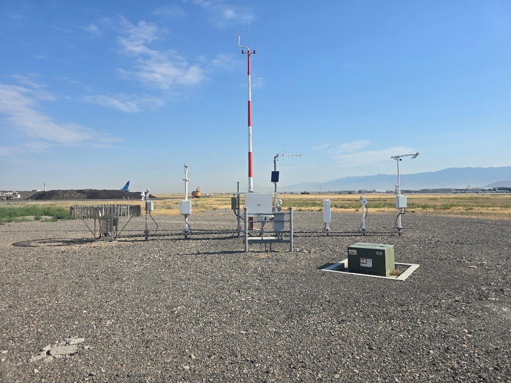
While the sensor has never been installed over grass, it has been installed over dirt, and now sits above some gravel.
(National Weather Service) The weather station at Salt Lake City International Airport.
So how much does that affect temperature readings?
On a sunny day in September 2022, NWS researchers did an ad-hoc test, comparing measurements from the official station (over gravel) to readings from five sensors a quarter-mile south that sat over dry natural grasses. The average temperature reading was higher in the gravelled area than in the grassy area — but only by 0.3 degrees. Readings varied from 102.7 degrees to 105.4 degrees during the 20-minute test across the five sensors, which does show there is significant variation possible.
In February of 2025, in accordance with a new nationwide standard, the sensor at the Salt Lake City airport was replaced with a new model, the Vaisala HMP-155E. It’s a shielded sensor to try to minimize various inaccuracies. It’s inspected every quarter and replaced every 18 months.
Furthermore, because airport readings are used so often, technicians verify the sensor’s readings more frequently (often monthly during the summer, they say) against an aspirated psychrometer (a fancy type of temperature-reading instrument that blows air across the thermometer) or a handheld temperature sensor.
There’s also an auxiliary temperature sensor at the site in case something goes wrong with the original, and if both were to break, there’s an official backup sensor at the Weather Forecast Office, which is also at the airport. There are a lot of redundancies here.
Claim 3: The station’s readings now have a bias towards higher temperatures
But a relatively quick test on one day may not be sufficient to see if the changes have really altered the station at SLC’s readings. The obvious thing to do, then, is to look at how the readings have really compared to those from other stations.
To do so, we’ll compare daily maximum and minimum temperatures at the airport station to those at seven nearby stations. To qualify for my list, the station needed to have daily readings for at least the last 30 years, must be at low or medium altitudes, and must have been within 50 miles of Salt Lake City.
Comparing daily maximum temperature readings at Salt Lake City International Airport compared to seven local weather stations that have continuously been recording data since 1995.
You can see that there are periods where readings at the airport were significantly hotter than those found elsewhere, most notably in 2014 and 2024.
Overall, there may be a somewhat positive trend in readings at the airport over the last 30 years. Before the station’s move in 2010, the readings averaged 0.65 degrees cooler than the other stations; after the move, they’ve been 0.4 degrees warmer. Also notable: when disparities have appeared, they seem to have disappeared almost as quickly.
However, we’re currently in a period where readings from the airport station are actually slightly lower than the output from other stations might lead you to expect.
Interestingly, a closer look at this data reveals that the biggest differences between the station at Salt Lake City International Airport and others are not during summer and for record highs, but during winter and for record lows. Those latter temperature readings at the airport clearly are higher than those found at nearby stations.
The station at Salt Lake City International “follows global trends in this area,” National Weather Service meteorologist Darren Van Cleave told me. “Data from around the world shows that nighttime and winter temperatures are warming at a faster rate than daytime or summer temperatures.”
He also noted that snow (which reflects sunlight, leading to cooler temperatures) is less common than before at SLC. Thirty years ago, there was an average of 53 days of at least 1 inch of snow on the ground at the station; now, that’s been reduced to just 26 days. That’s a change in surrounding conditions at the station — but an environmental one.
Claim 4: Sunday’s record wasn’t legitimate
Regarding Sunday’s record, it is also true that it was a record at only a minority of Northern Utah stations. While the measurements at Salt Lake City’s airport, Provo, Logan, Randolph, and Bountiful were record highs, there were at least 30 stations around the area in which Sunday did not establish a new record.
Stations that did — and did not — set an all-time high temperature record on July 12, 2026.
What caused this? Well, Van Cleave had me zoom out and look at the overall picture that day.
Records set throughout the northern area of U.S. and Canada on July 12, 2026.
Really, Salt Lake City’s stations were at the southern tip of a heat wave that was strongest throughout multiple northern states and even Canada.
And along the Wasatch Front: “Ultimately in our complex terrain, local effects can often be the difference between a couple of degrees, which will make or break whether a station gets to an all-time record or comes up just a little short,” Van Cleave said. “That can be things like lake breeze circulations, valley breezes, changes in urbanization near a site, etc.”
To try to exclude those factors when needed, meteorologists use readings from weather balloons. And at a barometric level of 700 millibars — around the crest level of the Wasatch range — the weather balloon’s readings also set a new high record by over half a degree on Sunday.
So I have to give the weather conspiracy theorists some credit: there have been some changes at the airport station that probably do affect readings, albeit by a much smaller amount than they claim. There’s also a reason that the weather experienced on Sunday may not have felt like a record — it actually wasn’t a measured record for many of the population areas around the Wasatch Front.
But even acknowledging there have been changes at the Salt Lake City station, the record of 109 degrees was by such a significant amount — two full degrees over the previous record of 107, even when measured by tenths — that there’s no real doubt that it was a legitimate one.
The overall picture certainly doesn’t point to tomfoolery here, but to a nearly 100-year history of scientists doing what they can to record conditions accurately. Is the data perfectly consistent? No, probably not: the biggest changes in Salt Lake City’s weather have been the result of outside-world factors — not the sensor itself.