facebook-pixel

As water supplies dwindle, Wash Co. seeks to pump aquifer

“The common sense thing to do is to slow the development,” New Harmony Mayor Lowell Prince wrote in a protest of the groundwater pumping plan.

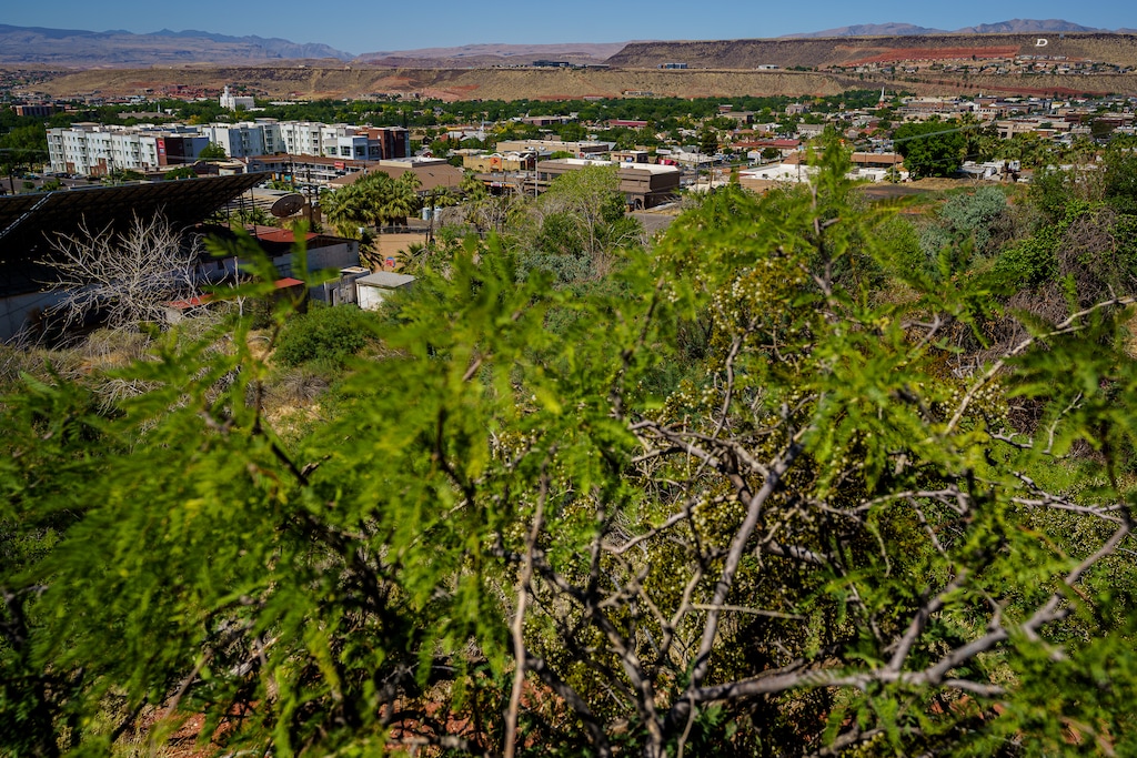
(Trent Nelson | The Salt Lake Tribune) The view of St. George from Temple Springs Nature Park on Thursday, June 10, 2021. In the face of rapid growth and long-term drought, Washington County water officials are seeking to pull groundwater from deep aquifers to the north of the city.

Editor’s note • This story is available to Salt Lake Tribune subscribers only. Thank you for supporting local journalism.

Yet another war over groundwater could be brewing in southern Utah.

With water supplies dwindling in the face of unrelenting drought and urban growth, Washington County water bosses are looking to pull nearly 13,000 acre-feet from deep previously untapped aquifers to sustain St. George’s fevered sprawl.

But residents of rural New Harmony and Kanarraville fear the proposed groundwater pumping plan would come at their expense, leaving them high and dry.

In a protest filed April 22, New Harmony Mayor Lowell Prince said the plan could force residents to drill deeper wells, while ignoring the actual source of St. George’s water shortfalls.

“Creating water rights where they don’t currently exist, and hoping there is indeed an underground river far below the known aquifers is dangerous for any of the existing wells and springs,” wrote Prince in the protest filed with the State Engineer. “If the St. George area needs more water from the water conservancy district, because they are developing too fast, the common sense thing to do is to slow the development. Our town feels very strongly that this action will have negative impacts on the levels in our wells and springs. You can’t rob Peter to pay Paul, it always ends badly.”

An incorporated municipality of about 210, New Harmony is located at the northern edge of Washington County, outside the water district’s service area. The historic farming town was settled in 1852 by Mormon pioneers in the shadow of the Pine View Mountains. Located midway between Cedar City and St. George off Interstate 15, it has retained its rural character while these larger cities have mushroomed.

Last month, the Washington County Water Conservancy District filed an application with the Utah State Engineer, seeking to draw water from 18 to be drilled along the Hurricane Fault, even though the state has already declared groundwater in this part of the Virgin River drainage “fully appropriated,” meaning that all its water is already spoken for.

District General Manager Zach Renstrom said the proposal is exploratory at this point, although the application clearly proposes actual diversions. Before the state can issue any new water rights, the district must show that the withdrawals wouldn’t impair existing water rights.

“That burden is on the district. So we have a fairly high standard that we’re going to have to meet before the state will issue any additional water rights, and I think that’s fair,” Renstrom said. “People are concerned about how this may affect their water rights. I think those are very valid concerns, and we wouldn’t want to do anything to affect their water rights.”

Washington County’s neighbor to the north pursued a similar strategy to meet the growing water needs of Cedar City but wound up depleting groundwater in the Cedar Valley, resulting in the land actually sinking in some areas. Now the Central Iron County Water Conservancy District is seeking to pump groundwater from 60 miles away in the Pine Valley, spurring a contentious fight with Beaver County.

But the Washington district says it would tap aquifers that are so deep that drawing from them will not affect other water users. The aquifers are identified as “C” and “R” in a 2013 study conducted by the Utah Geological Survey in 2013 at the district’s request.

“There is a scientific probability that there is this deep aquifer that has not been tapped, meaning the existing water that people are utilizing is not connected to this deeper water,” Renstrom said. “We want to get in there and find out if that’s true and do the science to look into this.”

Although the 2013 study recommended the district drill a test well into the footwall of the fault near Pintura, no exploratory drilling has taken place. Still, this and a 2016 study indicate existing water rights draw from basin-fill Navajo Sandstone and Kayenta formations, which are hydrologically separated from aquifers C and R, according to Renstrom.

“This is something that the district has been looking into for years. The district has paid for these studies, analyzed these studies. We’ve always said that we want to make sure we develop our local water sources,” he said. “I’d love to get down there and test this water. That will give us a lot of information about the date of the water and where it’s coming from.”

The district contends the State Engineer’s current conclusion that the groundwater is completely appropriated is based on studies that do not account for the deeper water it intends to tap.

“The C and R Aquifers represent an additional, unappropriated groundwater resource that is located in different strata and at greater depth than these relatively shallow aquifers,” the district’s application states.

Glen Whited of Double Deuce Stables in New Harmony isn’t buying the district’s claims.

“The drilling of these wells for a new water source is bull! If there is a deeper bath tub it has to run downhill to somewhere!” he wrote in a protest. “With Utah already using its allocated Colorado River Rights, it makes no sense to allow a new right of this size and [to] think that it will have no bearing on existing water [rights] is laughable!”

The district’s proposed wells would be spaced out for several miles north to south from Black Ridge, near New Harmony, to Hurricane, drilling down to depths between 1,000 and 5,500 feet. The water would be used for municipal purposes and some would be piped to Quail Creek and Sand Hollow reservoirs for storage, according to the application.

The public has until Wednesday to file protests with the State Engineer, the agency charged with deciding how water rights in Utah are assigned.

The land where the wells and pipelines would be placed is owned by the district, private landowners, and the Bureau of Land Management.

The water district, which is still pushing plans to deliver Colorado River water through the stalled Lake Powell Pipeline, already draws 4,000 acre-feet of groundwater from a network of 24 wells.

At least a dozen New Harmony residents besides the mayor have filed formal protests to the district’s bid for new water rights, all arguing that the scheme could take groundwater they depend on.

“I need to join my neighbors in hiring a Hydrology engineer to verify the claim that this is a new water source, not just taking and moving New Harmony water to St. George,” wrote Deanna Groke. “I need to stop any action on this until this is verified. I depend on this water source to provide for my family and farm.”