


This is an archived article that was published on sltrib.com in 2011, and information in the article may be outdated. It is provided only for personal research purposes and may not be reprinted.
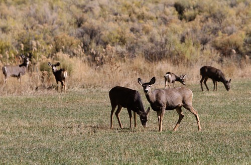
Book Cliffs • It feels like a road to nothing but flat tires and sedan-swallowing muck holes, a desolate dirt path rising past the Uinta Basin's oil patch to an alternate Utah that is home to several humans and several thousand mule deer.
Seep Ridge Road is a 45-mile portal from pavement's end to the Old West, where deer hunters wait years to win a lottery for a tag then drive their fifth-wheel trailers past decomposing log cabins from long-gone homesteads — too remote, physically and conceptually, for most solitude-seeking Utahns and tourists to even remember.
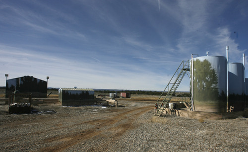
But it also is a road to this region's potential economic future, winding past existing natural-gas wells down low to envisioned well fields up top, and terminating near an experimental tar sands strip mine.
Now, in just one sign of the wild Book Cliffs' future taming, Uintah County wants to pave it. The mountains and miles between here and the Wasatch Front's millions of residents have kept the cliffs quiet, but the road signals an impending industrial squeeze. Thousands of gas wells are mounting on the west, vast tars sands and oil shale deposits beckon on the east, and an asphalt central artery could deliver everything from pipeline workers to Sunday picnickers from Vernal.
"It opens [the Book Cliffs] up for development of some of our natural resources," Uintah County Commissioner Mark Raymond said.
Besides the gas boom that has marched from the basin up the East Tavaputs Plateau toward the cliffs, area officials hope someday to support a tar sands industry currently being tested for viable energy extraction by a Canadian company.
"We want it done in an environmentally friendly way," Raymond said, "but we do believe in multiple use of our public lands."
The push is worrisome to big-game hunters nationwide who travel here partly for a wilderness experience and partly for trophy bucks that a select few get a shot at each year.
"The Book Cliffs are known for being one of the best hunting destinations in North America, especially in the United States," said Joel Webster, a Missoula, Mont.-based regional director for the Theodore Roosevelt Conservation Partnership. "If you're a mule-deer hunter, you definitely know about it. People put in for years to get a tag."
Webster has tried unsuccessfully for the past four years and has traveled to the Book Cliffs just to see what the fuss was about. He was not disappointed by the deer — he saw 30 in half a day — but was worried by the signs of development. His organization opposed the paving plan in formal comments to the U.S. Bureau of Land Management, which owns most of the land here. The agency has since reopened the study and will take comments through Feb. 15 before deciding this summer whether to approve the county's paving application.
"You're looking at an area that's receiving a lot of [industrial] pressure," Webster said, "and now you'll have a highway in there with people driving speeds you haven't seen, accommodating development. There's going to be some impacts there for big game."
The Salt Lake City-based Mule Deer Foundation also opposes the project.
—
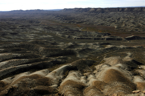
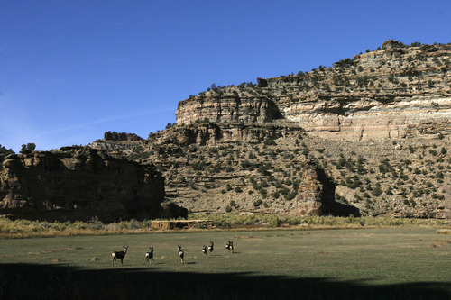
New chapter for Book Cliffs • With a corrugated front of scarps and canyons that vaguely resemble shelved books, the 2,000-foot cliffs arc for about 100 miles from Price to Colorado, hiding the East and West Tavaputs plateaus on their north flank. Biologists, hunters and BLM land-use planners use the Book Cliffs name to cover all of it, extending north in some places for dozens of miles from what geologists or cartographers would call the cliffs.
East Tavaputs rises from dusty badlands across a rolling gray mesa of sagebrush hillocks and forested arroyos, which are predominantly pinyon-juniper trees, then to a narrow band of moist highlands with Douglas firs and other greenery. Standing there, in the whistling wind at the Book Cliffs' edge, one can look north across the plateau and the lower basin to the High Uintas, then south to the redrock deserts below and the snowcapped La Sal Mountains beyond. It's a place where a panoramic camera might capture a quarter of Utah's enormousness, plus some of Colorado's.
West Tavaputs, separated from the rest by a wild stretch of the Green River, includes Nine Mile Canyon, where environmentalists and an oil company reached a landmark deal last year to allow drilling while protecting well-known ancient American Indian rock art and dwellings. Another planned gas field, proposed by Denver-based Gasco, would sink about 1,500 wells and carve 325 miles of roads in the rolling country north of Nine Mile Canyon.
The BLM is considering that proposal, and the Environmental Protection Agency has given it poor marks for likely contributing to the Uinta Basin's already-unhealthful ozone pollution. Rafting companies operating in the Green's Desolation Canyon complain that the wells would encroach on the river and their launch point at Sand Wash.
The Gasco project is south of Duchesne, where Mayor RoJean Rowley welcomes the jobs but is wary of another potential deal with environmentalists. The Nine Mile Canyon accord closed vehicular access to a high sliver of the plateau, she said, and she doesn't want any more of that.
"I'm opposed to closing off an area that only a few people can walk into or ride horses into," she said, "when some people — even our veterans who are handicapped or older — won't be able to do that."
The proposed well field is in pronghorn-antelope habitat and generally doesn't feed deer. The Uinta Basin's antelope populations have crashed by 75 percent in the past decade as the drilling boom has coincided with some drought years, said Ben Williams, energy-mitigation biologist in the Utah Division of Wildlife Resources' Vernal office.
Mule-deer advocates fear a similar fate awaits the Book Cliffs herd if gas-wells and tar-sands development grow in the high country. They point to western Wyoming's Pinedale Anticline, where a massive herd that winters on an intensely drilled mesa has suffered double-digit losses during the past two years, according to a consultant's report to the BLM.
Williams warned that new wells or tar-sands mining could hurt Utah's herd if they disturb much of the verdant strip near the cliffs. That zone provides the herd's only summer range, while lower winter range, in areas free of snow, is more plentiful.
—
Herd living 'on the edge' • The state, with help from federal agencies and conservation groups, spends millions each year protecting habitats like this.
Tory Mathis, DWR's habitat biologist in Vernal, oversees many Book Cliffs projects, mostly aimed at clearing pinyon-junipers that have encroached on sagebrush and grasses that are important deer foods.
Mathis also keeps an eye on areas disturbed by gas drilling. Non-native cheat grass and halogeton often are the first to come back, and they are no good for deer. Crews must apply herbicides to give native grasses and shrubs a head start.
"If we got a large increase in the oil and gas activity up higher, there might be some concerns," he said, and not just because human activity makes a range less inviting to deer. "You turn over the sod and it's almost guaranteed to come back as cheat grass and halogeton."
High-speed traffic is another matter. Seep Ridge Road has lots of curves and a dirt surface generally holds vehicles to 35 mph. The new route, if approved, would be straightened and posted at 55 mph. Williams ran a computer model suggesting that 50 mule deer does a year might die in collisions, a casualty rate that would diminish the herd regardless of mining and drilling. For that reason, DWR has worked with the county and the BLM to suggest fences and underpasses for deer crossing, which are tactics that have had mixed results elsewhere in Utah.
The Book Cliffs herd numbers about 7,500 deer, while the state's goal is 10,000. The population fluctuates with the weather, Williams said, declining in big snow years and rebounding in dry ones.
"It's on the edge," he added.
Tar sands and oil shale development pose threats because they require removing the earth to reach the oily rock — if companies can prove an economical way of crushing and heating it or otherwise extracting petroleum.
"They'd take everything out," Williams said, "and obviously we'd lose habitat to that."
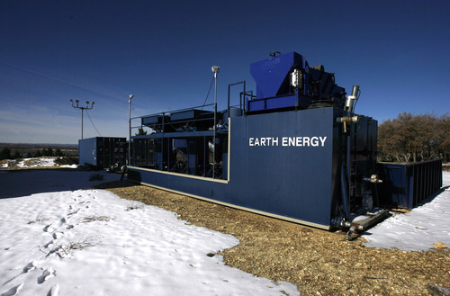
Canadian company Earth Energy Resources, with a School and Institutional Trust Lands Administration lease to test its process on Book Cliffs tar sands, has said that it constantly would restore the land in the wake of its pit mining. Williams said that could help retain deer habitat if the company sets aside the topsoil and returns it when the mining is done.
Earth Energy President Glen Snarr declined to comment on the project or the paved road that would serve it.
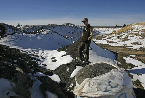
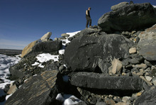
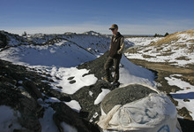
The company's existing PR Spring test pit is near where Seep Ridge Road reaches the top of the cliffs and feeds into muckier ranch and hunting roads that fan back out across East Tavaputs. There, tar — solidified in the cool air — has oozed out of upturned rock over a dammed pool of water and ice. Around the small development are pockets of fir and Gambel oak, flecks of green and brown in a sea of olive sage. A semi-trailer-size processing plant rests to one side, its conveyor belt waiting for more test product. On pallets by the road, someone has filled tarp bags with gravelly black sand that smells like used motor oil.
It's unclear how profitable, if at all, tar sands or oil shale mining could be here. Earth Energy claims to have a promising, clean process, but details are sketchy as the company remains silent while waiting out an environmental appeal with the state before mining more. The BLM's land-use plan for the area from 2008 predicted that tar sands likely wouldn't produce at commercial levels for at least 15 years.
—
A new wild card • The Book Cliffs have a major wilderness study area — Winter Ridge, on the southern East Tavaputs Plateau — but also tens of thousands of acres that could qualify under a new directive by Interior Secretary Ken Salazar. Last month he ordered the agency to review BLM lands for possible new restrictions in roadless areas.
"For people who take the time to explore it, it's quite a remarkable landscape," said Southern Utah Wilderness Alliance attorney Steve Bloch, noting he once spent the night with a stuck vehicle while exploring the East Tavaputs Plateau with friends.
SUWA opposes intense energy development in the plateau's remote areas and is especially interested in preserving Desolation Canyon, which includes an 89,000-acre roadless area, which the BLM so far has declined to protect for wilderness characteristics. The area is important to rafters, Bloch said, and offers archaeological wonders to those who get out of their boats and hike up side canyons.
The Seep Ridge Road project is what's left of an old idea to link Vernal to Interstate 70 in Grand County, home of Moab. That would require an expensive descent through one of the Book Cliffs canyons. Uintah County says it's not pushing to reach the freeway, but merely wants pavement to the county line. Grand County officials aren't buying it and have told the BLM so. They worry that an unwanted extension into their county would tax their maintenance budget with no real benefit to taxpayers.
"An improved road that ends at a county line in the middle of nowhere is obviously not going to remain that way for long," Grand County Commissioner Audrey Graham wrote.
Uintah County Commissioner Darlene Burns said it's enough just to get pavement to the cliffs, to give more people a chance at seeing the wilds. As it is, she said, shale rock that pokes up through the bed when the road is freshly graded can shred tires.
"There's a generation of older citizens," she said, "who are looking forward to this so they can just take a Sunday ride down there."
And then there are the handful who call the hills home, including rancher Burt DeLambert, who lives in a side canyon just off of Seep Ridge Road. He opposed a plan years ago, largely because it went right through his hay field. This time, though, the road would skirt his land, and he can see the need for change if more industry is coming.
"I don't think they're going to stop the gas business, because they've already got a lot of wells," DeLambert said. "Traffic and livestock's no good, and traffic and game is no good. But it's just part of life now."
Read the proposal
O Find the BLM proposal to pave Seep Ridge Road at tinyurl.com/4nua9bp