


This is an archived article that was published on sltrib.com in 2014, and information in the article may be outdated. It is provided only for personal research purposes and may not be reprinted.
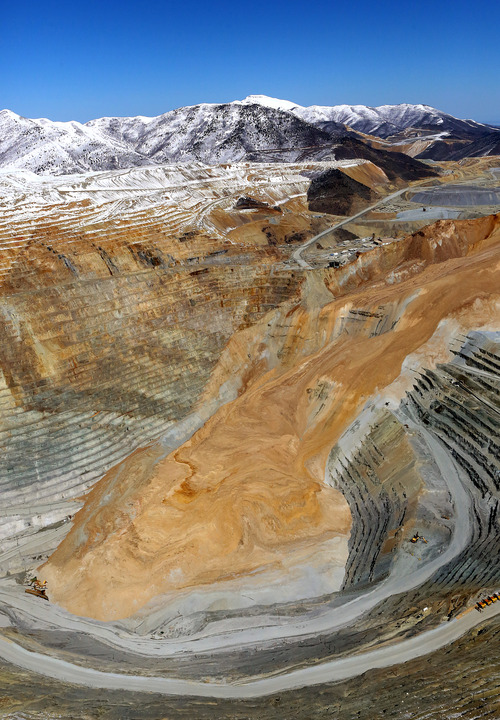
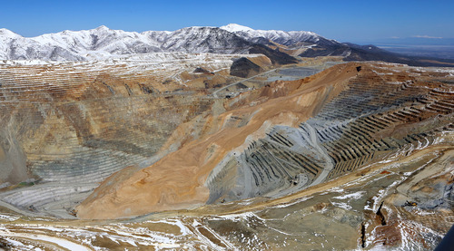
Accelerating to speeds of up to 100 mph, April's massive landslide in Kennecott's Bingham Canyon mine actually triggered earthquakes, the first time that is known to have occurred.A study by University of Utah scientists, published Monday on the cover of the Geological Society of America's magazine, GSA Today, said 16 small earthquakes were set off by the earth movement, which was mobilized by two rock slides 90 minutes apart."We don't know of any case until now where landslides have been shown to trigger earthquakes," said Jeff Moore, an assistant professor of geology and geophysics at the U. "It's quite commonly the reverse."Moore teamed with author Kris Pankow, associate director of the university's seismograph stations, who noted that numerous ground-movement sensors around the mine provided scientists with an immense amount of data about the April 10 landslide."This is really a geotechnical monitoring success story," Pankow said.Some of the key numbers:• The slides at 9:30 p.m. and 11:05 p.m. had magnitudes of 5.1 and 4.9, respectively, on various seismic scales. Each lasted about 90 seconds.• Right after the second rock slide, a real earthquake of magnitude 2.5 on the Richter scale was measured. A half dozen small quakes occurred between the two slides, the other 10 after the two, but none was detected in the 10 days before the event.• About 2.3 billion cubic feet of dirt moved in the slides. If Central Park in New York City were covered by that amount of dirt, Pankow and Moore calculated, it would be 66 feet underground.• The landslide traveled almost 2 miles — "much longer than we would see for smaller rockfalls and rock slides," Moore said, adding "We can safely say the material was probably traveling at least 100 mph as it fell down the steepest part of the slope." Its average speed: 70 mph. While both rock avalanches moved bedrock beneath the mine, the second contained a higher proportion of waste rock left over from Kennecott's mining operation.As a result, seismic data and infrasound recordings showed that the two avalanches were much different. Pankow said she hopes data from the Kennecott slides will enable U. scientists to understand the high-frequency energy waves released into the atmosphere by the movement."If we can learn what physical characteristics made the wave forms for the two rock avalanches different here," she added, "we can say more about the physics of landslides or rock avalanches that occur" in remote locations, such as in the Arctic.Pankow also expects the university team to learn more about the nature of these slide-induced earthquakes through further evaluation of Kennecott landslide data.She is interested in determining, for instance, whether earthquakes were taking place in this area before April 10 or if the measured quakes "were all just related to stress from the landslides."Moore characterized the Kennecott slide as "probably the largest nonvolcanic landslide in modern North American history" but noted there have been much larger slides.The 1980 eruption of Mount St. Helens in Washington unleashed a landslide 57 times larger than Kennecott's. In addition, a slide about 8,000 years ago at the mouth of Zion Canyon in southwestern Utah was five times the size of the slide in the Bingham Canyon pit. mikeg@sltrib.comTwitter: @sltribmikeg