


This is an archived article that was published on sltrib.com in 2013, and information in the article may be outdated. It is provided only for personal research purposes and may not be reprinted.
It's a rare day when a warning, watch or advisory isn't issued by forecasters at the National Weather Service.
But for people charged with protecting the public, such weather statements are anything but routine.
Lori Rome, chief of interpretation at Capitol Reef National Park in south-central Utah, said the staff works closely with forecasters to predict severe weather events such as flash floods. Forecasters come to the park every year to train the staff on safety during the monsoon season and to educate rangers on recognizing danger.
"We are taking official weather information daily," said Rome. "The National Weather Service calls us when they see serious potential for a flash flood. That has been so valuable."
If a significant wind, snow, rain, heat or fire danger event is expected on any given day, chances are at least part of Utah will be listed under some sort of weather designation.
On Monday, for example, the website of the agency's Salt Lake City office included an excessive heat warning, a heat advisory, a hazardous weather outlook and a special weather statement.
On Wednesday, the service noted the potential for isolated flash flooding throughout southern Utah on the Fourth of July.
But what's the difference between a watch, an advisory and a warning? And are standards the same for each National Weather Service office across the country?
According to Mark Struthwolf, a meteorologist in NWS Salt Lake City office, a "watch" is issued when conditions look favorable for a weather event in the near future. An "advisory" goes into effect when the weather is expected to be more of an inconvenience than a potentially life-threatening property issue. And a "warning" signals that a major weather event is imminent or occurring.
Agencies such as the U.S. Forest Service take such warnings seriously and work closely with forecasters on triggers for something like a red flag fire warning.
Brook Chadwick, assistant fire management officer for the agency, said a red flag warning could prompt his organization to bring in extra staff, begin alerting firefighters and mobilize resources from other parts of the west that has no such advisory.
"There is an extra heightened sense of awareness that this could be a bad day," he said.
Red flag warning triggers are fine-tuned each year. Fire fighters and forecasters look at years of data about the conditions on days when a fire started.
"When we see those conditions in the future, we know we have a good potential for a fire day," said Chadwick.
Standards for issuing weather statements vary around the country. For example, Struthwolf said heat advisory and warning guidelines in southern Nevada and Arizona differ from those in Utah. Forecasters and individual offices have been given more discretion in the last five to eight years to make judgment calls about weather events.
A fast-moving winter storm predicted to drop two inches of snow during the morning or afternoon commute may warrant a warning because cold, icy roads could have a major impact. But if that same type of storm hits at 2 a.m., with few people on the road, it might need only an advisory.
"The rarest warning [in Utah] is for a tornado," Struthwolf said. "The worst one for us and one that happens most frequently in the southern part of the state and can be the deadliest are flash flood warnings. Tornadoes are infrequent and rarely do we have any casualties. With flash flood warnings, we got a lot of them during the course of the year."
Twitter @tribtomwharton —
Watch or warning?
Here's a look at weather statements commonly issued in Utah and what it takes to trigger them:
Heat advisory • Issued in northern Utah when temperatures exceed 105 degrees, but relative humidity also figures into the formula. An advisory may also be issued if the high is only 100 degrees but humidity will make it feel warmer. In southern Utah, a heat advisory can be triggered at 110 to 114 degrees or when nighttime lows are higher than 80.
Winter weather • An advisory is usually issued when snowfall is going to be two inches or less, while a warning usually goes into effect when there will be three inches or more.
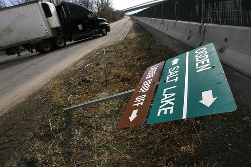
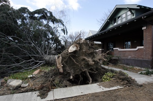
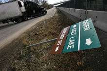
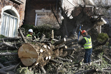
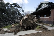
High wind • Warnings are issued when wind gusts of 58 mph or higher are anticipated in valleys, or when winds will reach 75 mph in the mountains. Advisories are triggered by winds expected to be 45 mph or more for three hours in valleys, or 58 mph in mountains.
Red flag warnings • Issued in advance of potentially dangerous fire conditions. Warnings are based on a combination of temperature, wind and relatively humidity and vary depending on the area of the state affected. They also may be issued if dry lightning is expected. Minor red flag warnings can occur when forecasters anticipate a long period of hot dry weather followed by wet or dry thunderstorms that could ignite a fire. They can also be issued if there is a strong wind shift associated with a cold front.
Source • National Weather Service