


This is an archived article that was published on sltrib.com in 2013, and information in the article may be outdated. It is provided only for personal research purposes and may not be reprinted.
An overnight storm — with high winds, booming thunder and sharp crackles of lightning — dropped up to an inch of rain on cities across the Salt Lake Valley, cooling off the region for the Fourth of July, flooding at least one apartment complex and leaving some residents without power.
Scattered showers and rain had been predicted, but the showers were more numerous and persistent than expected, National Weather Service meteorologist Steve Rogowksi said. It was the first rain to fall in the area since May.
"We only got a trace in June, so it was quite refreshing to wake up to the rain and the humidity," he said.
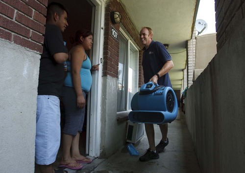
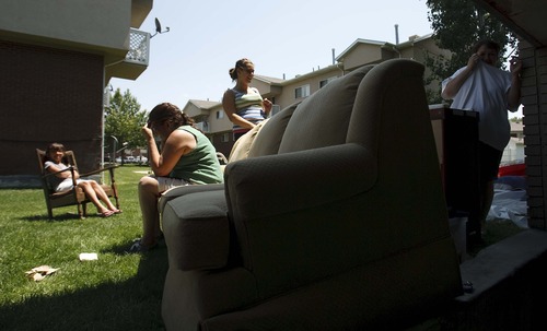
About 75 people were displaced by flooding at the Atherton Park Apartments, 4545 S. Atherton Drive (1110 West), in Taylorsville early Thursday after water backed up from storm drains and spilled into 24 basement-level apartments. Residents called 911 for help about 5:30 a.m., Unified Fire Authority Capt. Clint Mecham said.
Only four of the apartments suffered significant damage, he said.
No one was injured, but the Red Cross was at the apartment complex Thursday morning helping some families from the three evacuated buildings find temporary housing.
Despite its flooding, Taylorsville didn't record the most rain from the storm. Weather service data shows Holladay got the most rain, with just over one inch. Salt Lake City recorded .43 of an inch, but the showers tapered off to the north and south, with only traces of rain seen in most of Davis, Weber and Utah counties.
At least 3,000 people across several Salt Lake City neighborhoods were without power for a period of time overnight after an electrical pole caught fire. Power had been restored to most customers just before 8 a.m., according to a post on Rocky Mountain Power's website.
Strong winds also blew in with the storm, with gusts as high as 69 mph recorded at about 3 a.m. in Syracuse, and 40 mph at the Salt Lake City International Airport. Gusts of 59 mph were recorded at the Salt Lake County Flight Park at Point of the Mountain, 46 mph at the University of Utah and 40 mph at the Great Salt Lake Marina.
Temperatures Thursday climbed to 93 degrees in Salt Lake City and 91 in Tooele. The high for Ogden was 90, Logan hit 89, and Provo reached 95.
The Fourth of July holiday didn't bring St. George or Zion National Park any independence from the scorching temperatures, however. Temperatures there reached 109 and 111 degrees, respectively.
On Friday, temperatures are expected to reach the 90 in Salt Lake City and 89 in Tooele, with a continued chance — 30 percent — of rain and thunderstorms. Northern Utah's Cache Valley should also see temperatures in the low 90s, with a 30 percent chance of rain. The southern Utah forecast calls for temperatures of about 106 degrees and a 20 percent chance of rain.
Twitter: @jenniferdobner