

This is an archived article that was published on sltrib.com in 2010, and information in the article may be outdated. It is provided only for personal research purposes and may not be reprinted.
Cedar City • The geologic wonders of Zion National Park were created by rock slides, earthquakes, landslides, flooding and debris flows. But those forces are a threat to tourists and people who live in surrounding towns and along the popular highway leading into the park.
A recently completed survey of the region, based on existing maps of the hazard-prone areas, will help park managers protect visitors as they plan future construction. The study, by the Utah Geologic Survey, took two years to complete.
Carol Harlan, who lives in Rockville, near the park, said she and her husband have traveled to take photos near dust clouds that signal a rockfall from the cliffs north of town.
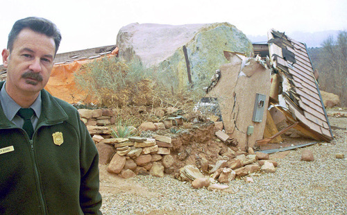
In 2001, a 300-ton boulder destroyed the new house of a Zion employee. "In that one I disappeared in a hole it left," said Harlan.
It's something residents have dealt with since the area was settled.
"Throughout town there are stories of people who moved their houses on skids pulled by horses," she said. "A [boulder] would hit their barn and the wife would say she doesn't want to live there anymore."
The new study includes nine maps that show areas subject to flooding, debris flows, rock fall, landslides, surface faulting, liquefaction, collapsible and expansive rocks and soils, and/or soil piping and erosion.
Zion attracts about 2.5 million visitors each year.
William Lund, a senior geologist with the UGS, said the Zion survey report will help park managers avoid the kind of mistake they made a decade ago when they built a greenhouse without a floor. The ground beneath it collapsed after water used on the plants seeped into the dirt. Such cave-ins happen when clay and silt that bind soil grains in a honeycomb-like structure are washed away.
Dave Sharrow, a hydrologist for Zion who worked on the study, said the park has experienced "screaming-fast erosion," geologically speaking. Since 1950, there have been 20 deaths in Utah because of flash floods, eight of them in Zion.
While park officials are well aware of the potential for flooding, the survey will help them locate the safest places for new construction.
"Visitors to the park stay for a few hours or couple of days; we have employees who are here all the time, and we want to keep them out of life-threatening situations," he said.
Growing numbers of backcountry campers are also a concern. Sharrow said the hazard study can help managers establish camping sites in safe areas.
Now that the Zion report is finished, Lund said he and his team will conduct a similar study along the State Road 9 corridor between the park entrance in Springdale and the town of La Verkin.
Rockville Mayor Allen Brown asked for that survey in February after a huge chunk of Navajo sandstone rolled off the cliffs and broke apart, smashing into a house.
Brown said the upcoming survey will provide solid data for future planning and alert landowners to potential problems. He said the town will assist by collecting information about past significant rockfalls.
"If you want to know how Rockville got its name, just look up," said Brown.
Gary Zabriskie, director of community economic development for the Five Counties Association of Government in the area, said the $60,000 cost of the study will be shared by the UGS and a $28,000 grant from Permanent Community Impact Fund Board. Corridor communities will contribute $500 each.
"This [study] will allow cities to reinforce ordinances with information to back them up," said Zabriskie. "It gives them another tool in implementing [development] plans." —
Read report
O The Utah Geological Survey study of hazards in Zion National Park and surrounding areas is available for $24.95 at the Natural Resources Map & Bookstore, 1594 W. North Temple, Salt Lake City; it can also be viewed on the UGS website.