

This is an archived article that was published on sltrib.com in 2016, and information in the article may be outdated. It is provided only for personal research purposes and may not be reprinted.
After years of meetings, discussions and a little horse trading, the Bureau of Land Management this week released final management plans for two national conservation areas (NCAs) near St. George. But the long-awaited decisions are not likely to resolve controversy over a proposed highway Washington County officials say is badly needed and was promised to them by Congress.
While the BLM made some concessions to local and state officials while crafting the final plans for the Beaver Dam Wash and Red Cliffs conservation areas, it did not budge on its refusal to designate a major transportation route across tortoise habitat just north of this fast-growing metro area.
"That doesn't mean it's done. I'm sure it will end up in federal court at some time," said Mayor Chris Hart of Ivins, a town near what would be the western terminus of the "northern transportation corridor."
Ivins said locals feel the route was part of the 2009 omnibus bill that established new NCAs and wilderness in Washington County. "We don't have a lot of options for crossing this county east to west."
Hart was among several local officials who formally protested the BLM's preferred Red Cliffs alternative, identified in an environmental impact state released earlier this year.
In resolving protests concerning the transportation corridor, the BLM conceded that a multi-lane highway would spur economic activity and employment and reduce traffic pressure elsewhere. But forging such a major artery "would negatively impact a majority of the unique resources that the NCA was created to protect and their nonmarket values," the agency concluded.
Still, the door is not closed on the transportation corridor; it just has a very high threshold to win approval should the county seek a right of way, according to Brian Tritle, the BLM's St. George field office manager
"It won't be easy; it should be tough," Tritle said. "We have an avoidance area. What this means is we prefer not to route a road here. In this case it is critical habitat for Mojave desert tortoise and it's in an NCA with myriad interdisciplinary conservation values. ... We all know folks are coming to Washington County. It's not only for affordable houses. It's the views, it's the access to recreation and the other things the NCA provides."
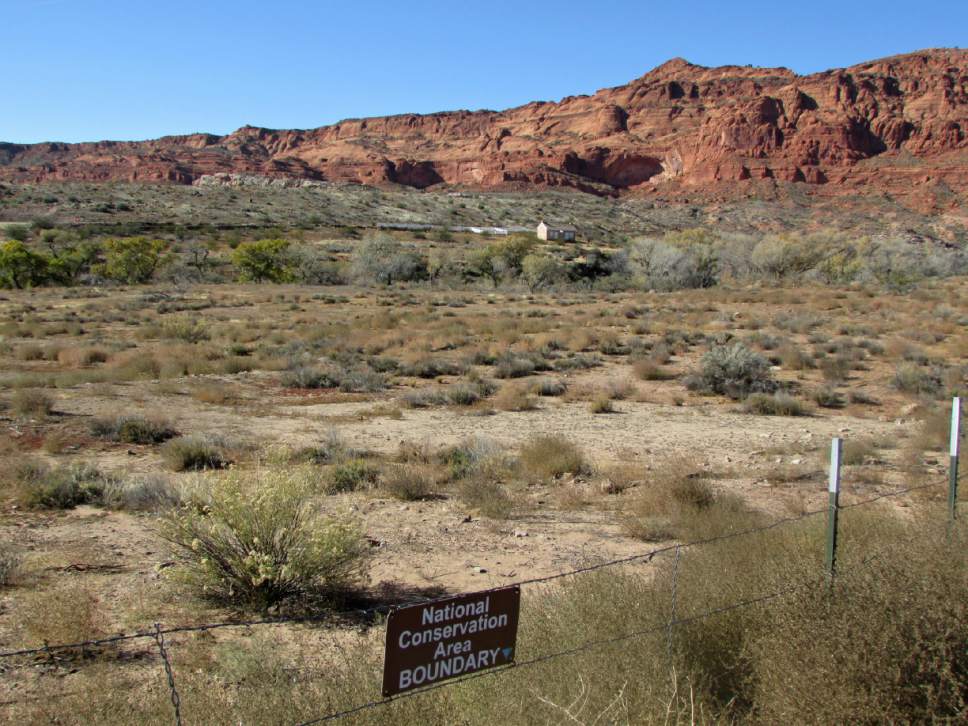
Beaver Dam Wash covers 63,478 acres of public lands populated with Joshua trees and migratory birds in Utah's southwest corner. The Red Cliffs NCA protects 44,859 acres bordering St. George subdivisions and harboring the Mojave desert tortoise, a federally protected species whose habitat occurs almost exclusively in the most the rapidly developing parts of the desert Southwest.
These NCAs were set aside as part of a massive lands bill, which Utah Sen. Orrin Hatch now claims included provisions that would allow a corridor envisioned by metropolitan planners.
Conservationists and BLM officials dispute such a commitment was ever made. Congress established the two NCAs to conserve and enhance their "ecological, scenic, wildlife, recreational, cultural, historical, natural, educational, and scientific resources." Activists say Washington County can address its transportation needs without sacrificing vital open space that the NCA also preserves for human recreation and scenic enjoyment.
Federal wildlife officials wrote that the proposed corridor would not only consume habitat but also isolate tortoises on the southern portion of the reserve, defeating the purposes of a long-standing tortoise preserve that predates the NCA.
But Hart and other officials contend the road could include wildlife passage features that would enable tortoises to get from one side to the other.
"The whole thing is so ridiculous," Hart said. "That route can be built without creating serious problems for the tortoise population. There is engineering and scientific evidence to support that view, but the conservationist lobby refuses to acknowledge that. ... Nobody can identify real harm, except for separation of [tortoise] populations, which can be easily mitigated by underpasses."
The 6,534-acre footprint the BLM identified for the corridor grossly overstates its impact, according to Hart, who contends it would be closer to 100 acres.
To the mayor, a self-described conservation-minded developer, the plan should strike a balance on the road question but has instead erred on the side of protecting habitat at the expense of human needs and other environmental considerations.
"It depends on what you consider to be harm to the tortoise. If you are purist or extremist, anything that disrupts their habit is detrimental. Where is the practical balance?" Hart said. He believes residents' transportation needs far outweigh what he considers the minimal harm a route would inflict on the tortoise.
The new management plans, however, do account for human needs and this area has been a tortoise preserve for the past 20 years, Tritle contends. The county agreed to the preserve to free up tortoise habitat elsewhere.
"We have a legacy of protective management, not only for the tortoise, but the other special values there and recreation. We will work to enhance recreation on the NCA. As for scenic and culture resources, we will look for more opportunities to interpret those, but the most important thing is to protect those resources for future generations," Tritle said.
Twitter: @brianmaffly