


This is an archived article that was published on sltrib.com in 2016, and information in the article may be outdated. It is provided only for personal research purposes and may not be reprinted.
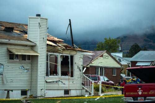
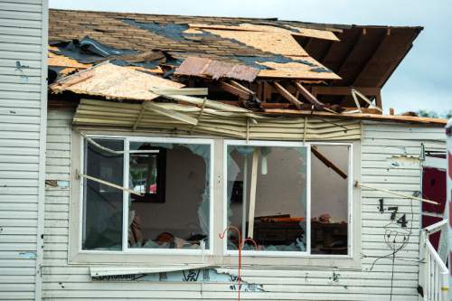
Washington Terrace • Pieces of Gaelynn Sewell's house were strewn across the neighborhood — a brown shingle across the street, some broken glass on the sidewalk, chunks of wood on the grass.
She cries when she thinks about the damage, how what was once her "dream house" is now in shambles, how she had to go to the store to buy a toothbrush and clean clothes when she used to have everything she needed.
"We lost things that can never be replaced," Sewell said Thursday after a tornado destroyed her Washington Terrace home while she braced for the storm inside. She walked away from the house in shock, with cuts on her leg and sore ribs.
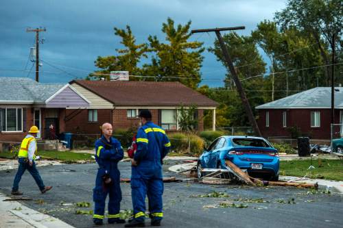
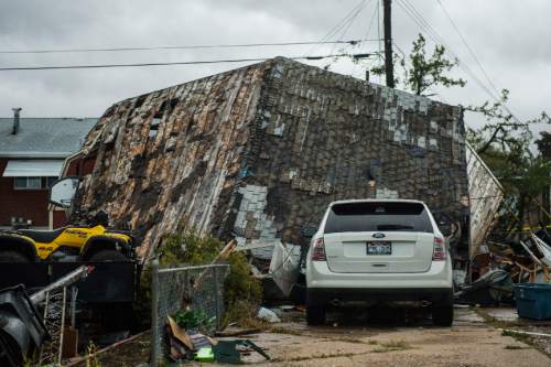
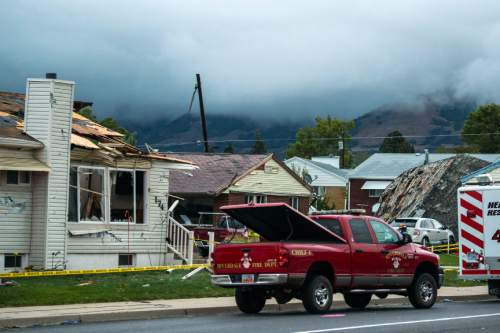
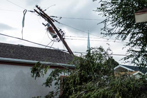
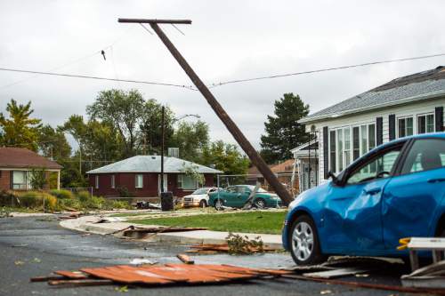
The funnel cloud, which wreaked havoc for about two minutes after touching down at 3:45 p.m. in a neighborhood near 200 East 4700 South, damaged at least 30 homes, said Weber County Sheriff Sgt. Matt Jensen. Sewell's was the sole house — with its roof torn off, frame exposed and windows broken — deemed a complete loss.
And though her husband went back to the house to collect Sewell's wedding ring, anything that wasn't shattered amid the high winds — including the coffee cup from her father, who died this past year — was rained on. Though she was initially shocked, Sewell said she's coming to terms with the fact that the house she's lived in for the past 22 years with her spouse and two children is gone.
"We'll take it one day at a time," she said.
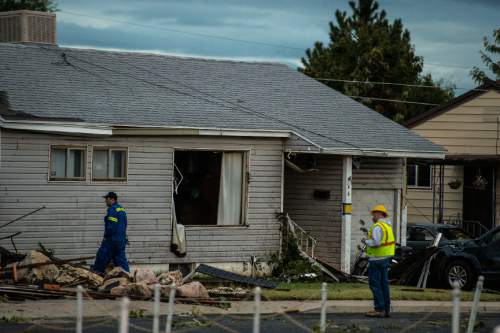
Sewell and her family are staying with her siblings while insurance claims process. Many others have sought temporary shelter in a nearby senior center while the gas, water and power lines are disabled at their houses, Jensen said, making many of them uninhabitable until resources are restored.
Several dozen homes had "severe damage," and at least 12 have "extensive damage," according to a news release.
"It's going to take days, if not weeks, for cleanup," he said.
Minor injuries were reported, and there's no cost estimate for the damage, though Jensen says it will be a high.
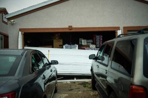
Jared Brown was working about 6 p.m., boarding up the garage on his father's house, who's lived across the street from the Sewell house for 25 years. A strong gust blew out the windows in the back of the house, swept through the home and pushed out the garage door, Brown said, leaving "quite a big mess."
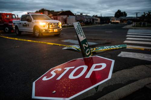
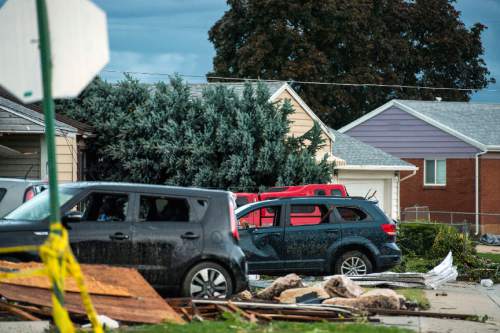
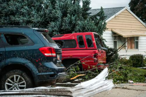
Wreckage covered the streets of the neighborhood. A metal stop sign was bent in half from the force of the winds, and at least 25 felled trees lined nearby parking strips. Power poles tumbled, garages caved in and sheds ascended several feet away from where they used to be secured.
Louisa Heniger, 42, and her husband, Jared, 40, live two blocks away from the area hit the hardest and saw the winds and rain pick up while they were at a nearby store. They walked to Sewell's house to survey the damage.
"It sounded like Armageddon," Jared Heniger said of the storm.
The area near 5000 South Ridgeline Drive in Washington Terrace also was "hit pretty hard," Jensen said, noting that the believes the tornado touched down in several spots in the city, coming from the southwest.
"It was a chaotic scene," he said.
Bonneville High School, T. H. Bell Junior High, Washington Terrace Elementary and Roosevelt Elementary in Weber County will be closed Friday as a result of damage in the area, the release states.
Another tornado hit Panguitch just before 7 p.m. — the second time the city has seen one in less than a month — ripping the roof off a building at 609 N. Main Street and damaging a house to the north.
The tornado then traveled northeast, damaging at least one home near 800 North and 250 East. The Garfield County Sheriff's Office said reports of damage were still coming in late Thursday night. There were no serious injuries.
A meteorologist will assess the damage done by the two tornadoes Friday, said Brian McInerney with the National Weather Service, and give them a classification from F0 (less than 73 mph winds with light damage) to F5 (261-318 mph winds with incredible damage).
The last time Utah experienced such a destructive tornado was Aug. 11, 1999, when an F2 funnel traveled through Salt Lake City from about Interstate 215 to Interstate 15 and left one person dead.
Elsewhere in the state Thursday, extensive flooding in southern Utah and well as heavy rainfall and hail to the north left their marks.
Clearfield, Layton and Syracuse saw up to an inch of hail, according to the weather service. Antelope Island State Park, on the Great Salt Lake, reported golf-ball-size hail and 60 mph winds with limited visibility, McInerney confirmed. The storm ripped the roof off of the island's Fielding Garr Ranch, which is closed until further notice.
The weather service also reported downed trees in Layton and 81 mph winds in South Ogden, while winds at Ogden Peak reached 101 mph. Hill Air Force Base clocked winds at 75 mph.
Sunnyside, a city in Carbon County, reported 4 inches of rain. Widespread river flooding occurred in "every waterway" in southern and eastern Utah, McInerney said, sending an inch to an inch and a half of water to the ground.
The north fork of the Virgin River, which runs through Zion National Park, increased from 40 cubic feet per second (cfs) to more than 2,000 cfs in a "very short period of time," McInerney said. Nearby rivers rose at about the same rate.
The park closed its slots under a flash-flooding warning until further notice.
A flash-flood watch extended to parts of Kane and Washington counties, including Hildale. The weather service said to expect heavy rains and fast flows in streams and washes. A watch also was issued for Capitol Reef National Park and Glen Canyon National Recreation Area, including Grand Wash, Capitol Gorge, St. George and Price.
A flash-flood warning was issued for northern Uintah County until late Thursday night. Affected cities included Vernal, Fort Duchesne, Whiterocks, Naples, Ballard, Maeser and Randlett.
On the east side of the state, McInerney said, there was flooding from the Green River up to Duchesne County. The Price River also expanded, flooding homes.
Due to the storms, about 10,300 customers were without power in Uintah, Ogden, South Ogden, South Weber, Riverdale and Washington Terrace. About 10,700 customers were without power in Clearfield, Clinton, Hooper, Layton, Syracuse and West Point. About 551 customers in Salt Lake City (zip code 84111) were reported without power about 10:15 p.m.
Rocky Mountain Power did not have an estimated time of restoration, though a tweet said crews would be working through the night.
Some flights at Salt Lake City International Airport were delayed, according to a tweet from the airport, because of the weather.
The weather service also said winds caused some roofs to collapse in Layton.
While the bulk of the storm had passed by Thursday night, a weather service spokesman said snowfall was anticipated at altitudes 7,000 feet and above. Albion Basin Road in Little Cottonwood Canyon was closed.
A winter weather advisory was issued for areas in the western Uinta Mountains, including Alta, Brighton, Randolph, Woodruff and Mirror Lake Highway, from 9 p.m. Thursday to 10 a.m. Saturday. Six to 12 inches of snow is expected.
The Great Salt Lake desert and mountains, including Wendover and Snowville, were under a wind advisory from noon to 11 p.m. Thursday. Strong crosswinds could affect travel in the eastern portion of the state on State Route 30 and Interstate 80.
A wind advisory was in effect 9 a.m. to 11 p.m. Thursday in west central and southern Utah, including Delta, Cedar City, St. George, Bryce Canyon, Kanab, Hanksville and Lake Powell.
Thursday was the first day of autumn.
Twitter: @courtneyltanner
@mnoblenews
— Salt Lake Tribune reporter Pamela Manson contributed to this report.