


This is an archived article that was published on sltrib.com in 2016, and information in the article may be outdated. It is provided only for personal research purposes and may not be reprinted.
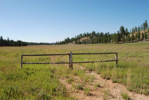
Bryce Canyon City • Stands of ponderosa cover the rolling terrain on the Paunsaugunt Plateau outside Bryce Canyon National Park, where broad meadows are tucked between low ridges.
Around Dave's Hollow near Ruby's Inn, unauthorized routes crisscross these meadows and trail into the woods, some going nowhere in particular — inflicting scars on the landscape that the Dixie National Forest has been trying to reclaim.
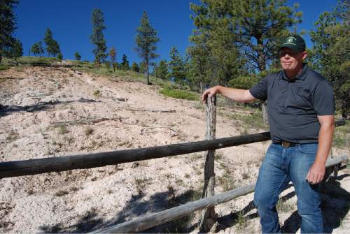
Before a ban against cross-country motorized travel took effect in 2005, this area was known as "the spaghetti bowl" because of all the unnecessary user-created paths, Powell District Ranger Paul Hancock said last summer during a visit to Dave's Hollow, gazing at an eroded track cut by off-roaders up a hill rising above a meadow.
"I have to maintain a sustainable road system, one that meets resource needs and management needs," Hancock said. "We want roads located in good locations. We are trying to find the balance. It isn't everything open to the public."
Dixie crews have been gating, blocking and obliterating routes slated for retirement under a motorized travel plan adopted in 2009, much to the consternation of local and state officials who allege they're shutting down public access. Garfield County says now-closed routes are not just part of a vital "transportation network," but are "cultural resources" that ought to be surveyed and preserved with the same care given to ancient American Indian sites.
According to County Commissioner Leland Pollock, then-forest supervisor Rob MacWhorter crafted the plan in the late 2000s behind closed doors with environmentalists at the table. Pollock characterized the decision MacWhorter signed as a "road-closure plan" that excludes the public.
"When you close 75 percent of the roads, you are going to have wilderness without congressional authority," Pollock told a legislative panel. "Here we are in this ocean of federal land and we need to protect our people. ... It's not just about health, safety, welfare. You want to see this forest, you want to enjoy it, but you cannot if you have all these road closures. You can't get anywhere on the Dixie."
Residents no longer can drive to favorite camping and fishing sites, and emergency crews may not be able to reach fires promptly, according to Pollock and other rural county commissioners.
"That's utter twaddle; they have fetishized roads. Roads have a value that exceeds all others, so wildlife suffers, water quality suffers, solitude suffers and you wind up getting a human-dominated landscape," said Mark Clemens, director of the Sierra Club's Utah chapter.
Federal documents indicate more than half — 2,700 miles' worth — of the Dixie forest routes remain open to public use, and another 1,000 miles are closed but maintained for administrative use. According to Dixie forest officials, the 1,500 miles to be decommissioned were deemed unnecessary, routed through sensitive land or too costly to maintain after careful study by a team of scientists.
The decision was made after "full and open public involvement," according to Intermountain Region forester Nora Rasure.
"We believe the motorized travel plan enhances recreation experiences, improves roads and trails, protects drinking water, protects meadows and wetlands, and provides room for wildlife to roam," she said. "We are committed to being good neighbors in all of the communities where we have responsibility to manage public lands. We have the ability to look at changed conditions, additional needs or things that need to be adjusted, and through another public involvement process, make changes."
Rep. Mike Noel, R-Kanab, stepped in this legislative session with HB367, a bill that would authorize sheriffs in Garfield, Iron, Kane and Wayne counties to "remove" any road obstruction if they can show it "adversely affects the public health, safety and welfare of the people of the political subdivision by obstructing travel that is necessary for the maintenance of natural resources; or another public purpose."
"They are closing down lots and lots of roads in the national forest. It restricts the public's access to utilize those roads. It doesn't allow, when forest fires occur, access to put fires out," Noel told a legislative panel. "Some are Forest Service roads, but we have paid all the moneys to maintain them, and when they indiscriminately close them all down, it affect us in terms of fire, recreation and all kind of areas."
His measure sailed through the House, but it died in the Senate without a floor vote — the same fate a similar bill met the year before.
While environmental groups say local governments had ample opportunities to influence Dixie forest personnel's decision-making process, county officials say the final plan is a "mess" based on faulty data, provided largely by "special interests."
"By 2011, everyone could see it was a nightmare; even the Forest Service guys knew it was a problem," said Brian Bremner, Garfield County engineer.
Two years ago, the Utah Legislature enacted its own travel plan. A map supporting the state plan depicts the Dixie forest resembling a color-coded spiderweb, with open routes in blue and those that have been closed or retired in red.
Garfield County says all those routes are county "highways"; it filed a formal appeal to the 2009 travel plan, alleging Dixie National Forest officials breached data-quality standards.
According to Bremner, Garfield withdrew the complaint when officials agreed to revisit the travel plan — starting last year with the Powell District. Dixie officials initiated an environmental impact statement, conceding that 48 miles slated for retirement should be re-evaluated because these routes access dispersed recreation sites. They decided another 10 miles of open routes could be worth decommissioning.
But last fall, Dixie officials put the environmental analysis on hold. This prompted the Garfield County Commission to adopt an "emergency" resolution, calling on them to recognize the state plan — which provides "the minimum transportation network necessary to protect the health, safety, welfare, custom, culture, and heritage of lands and people in Garfield County."
"We are trying to maintain the historic and cultural access to the forest," Bremner said. "We are not talking about raping and pillaging."
He claimed new federal rules designed to keep sage grouses off the endangered species list derailed the reopened road analysis for Powell District.
According to Dixie spokeswoman Marcia Gilles, however, the forest is in discussions with Garfield County to broaden the stalled analysis to "a landscape level" — possibly including other projects like timber harvests, prescribed burns, forest restoration and habitat improvement.
The county resolution claims it is entitled to many of the Dixie routes under RS2477, the repealed 19th century statute that grants rights of way to roads that counties built across public land. Southern Utah's forest reserves were established a century ago, however, and it would be unlikely any county could legally prove routes were in use back then — particularly tracks cut by motorized off-roaders like those in Dave's Hollow.
Brian Maffly covers public lands for The Salt Lake Tribune. Maffly can be reached at bmaffly@sltrib.com or 801-257-8713. Twitter: @brianmaffly