


This is an archived article that was published on sltrib.com in 2015, and information in the article may be outdated. It is provided only for personal research purposes and may not be reprinted.
Grafton • The more than three million visitors that descend on Zion National Park each year no doubt enjoy the hiking and scenery at one of America's prime locations.
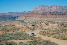
But as they pass through the tiny hamlet of Rockville on the way to the park, the vast majority drive right past the historic single lane bridge, the Grafton ghost town and cemetery and the 9.25-mile long Smithsonian Butte National Back Country Byway.
That might be a good thing for several reasons.
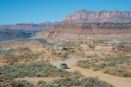
First, while the dirt road is often graded, it can be treacherous after a rainstorm. And a rugged part of the byway the Bureau of Land Management calls "Crybaby Hill" can be a challenge for inexperienced drivers in low-clearance two-wheel-drive vehicles not made for rough, rocky conditions.
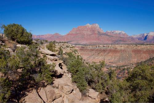
Second, there is a certain joy for those who get off the beaten track on a place such as Smithsonian Butte. It is often quiet in this spot. There is time to look at scenic vistas that include Smithsonian Butte, Eagle Crags, Vermillion Cliffs, the Canaan Mountain Wilderness, Gooseberry Mesa, Wire Mesa, Pastry Ridge and, of course, the sandstone buttes of nearby Zion.
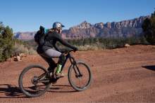
Margaret Ososki, who lives in Apple Valley on the southern end of the back way, stays in shape by riding her mountain bike along the road where she said she sees few people but plenty of pretty scenery.
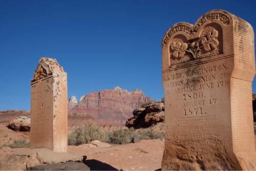
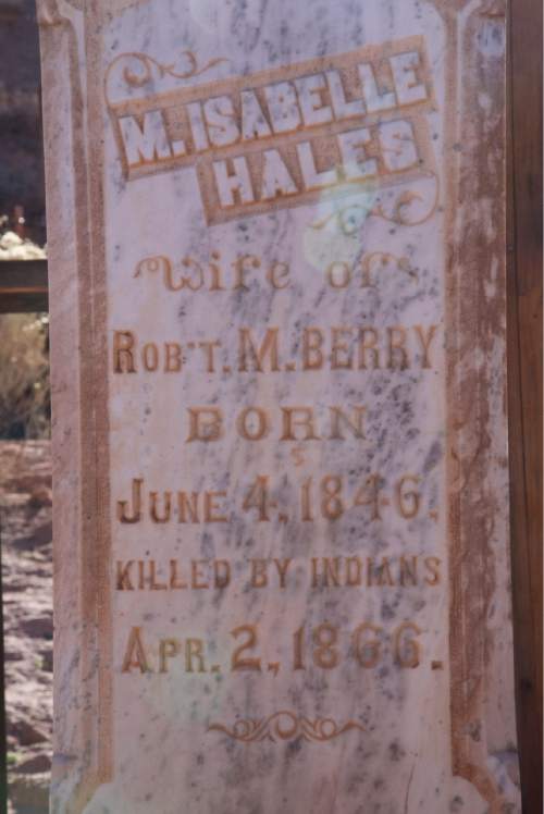
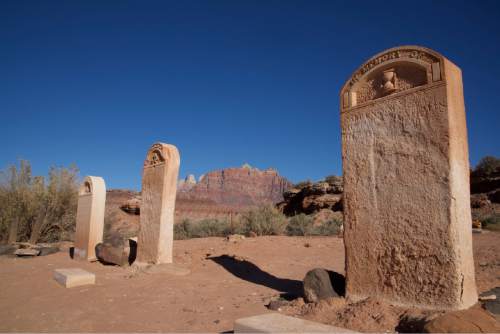
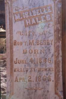
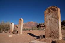
There is also a reverent quiet at the Grafton Cemetery, which contains between 74 and 84 graves dating from 1862 to 1924. Weathered stone headstones only hint at the hardships settlers to this area faced when called to try to raise cotton on the banks of the Virgin River by Mormon church leaders.
An interpretive sign placed by the Grafton Heritage Association near the graveyard offers history of the area including what it calls "the hard year of 1866." That's when 13 people in the small community died, some killed by Indians, others when a swing broke and a few by diphtheria and scarlet fever.
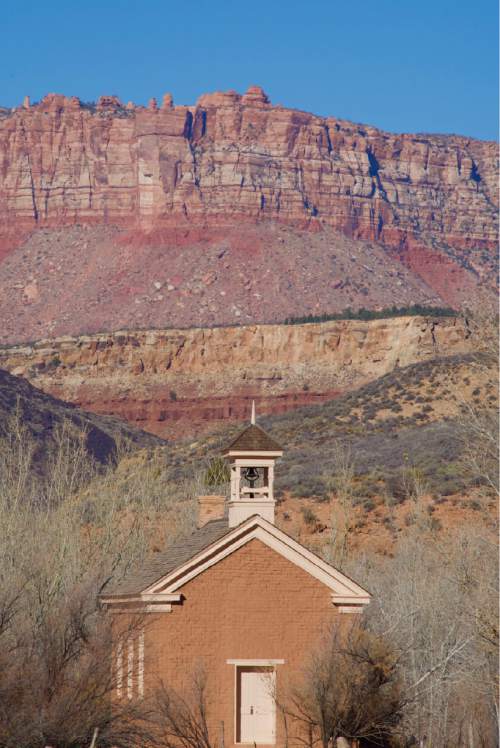
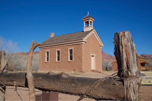
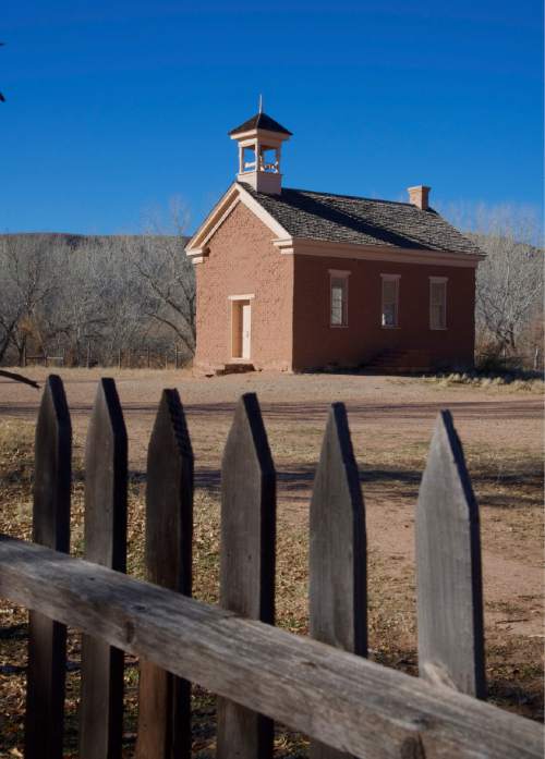
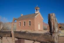
The Grafton townsite, made famous in the bicycle scene from the movie "Butch Cassidy and the Sundance Kid," can be seen a few blocks further down this dead end road.
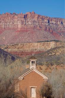
There, the schoolhouse/church built in 1886 but last used in 1919 stands. It was built using wood brought in from Mt. Trumbull, 75 miles away. The Alonzo H. Russell House, constructed in 1862, also stands.
Though some development and some new homes have been constructed nearby, the townsite has changed little since the last resident left in 1945.
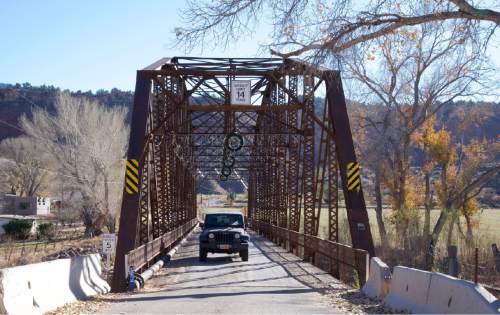
Those starting or ending an exploration of this area need to drive across the one-lane Rockville Bridge, which was constructed across the Virgin River in 1924 and is the only surviving Parker Through Truss-type bridge left in Utah.
According to the town of Rockville, the bridge — which is listed on the National Register of Historic Places – provided the primary automobile route for visitors to Utah's Zion national park.
At Christmastime, decorations and lights hang from the top of the bridge. The town is looking to preserve the bridge, which is deteriorating due to heavy use and age.
While a new bridge may be built, the town is raising tax-deductible donations to preserve the historic bridge. For information, log on to http://www.rockvilleutah.org.
Dave Kiel, a BLM recreation planner in St. George, said that the Smithsonian Butte Road can be rutted after a rainstorm.
Kiel suggests contacting his office or inquiring locally before trying the back way, especially if attempting it in a low clearance vehicle.
He said a nearby mountain biking area called Gooseberry Mesa National Recreation Trail is the southwestern Utah version of Moab's Slickrock Bike Trail.
"It has mountain biking loops that are incredibly popular," he said. "There are restrooms, trailhead parking and informational kiosks. Dispersed camping is allowed."
That said, camping is prohibited on federally managed lands within one-half mile of either side of the Back Country Byway.
The 9.25 miles takes only about 45 minutes to drive if conditions are ideal. But take time to explore the Grafton ghost town and cemetery, to stop for a few photos or to simply savor the silence and the scenery.
Twitter: @tribtomwharton —
Smithsonian Butte National Back Country Byway
P The 9.25-mile byway is located between Rockville on State Route 9 and Apple Valley on State Route 59, just south of Zion National Park, and can be accessed in either direction. It may be too rough for two-wheel-drive or low-clearance vehicles, especially after recent rains.
• For information, log on to the BLM's St. George Field Office site at http://www.blm.gov/ut/st/en/fo/st__george.htm, http://www.graftonheritage.org or http://www.rockvilleutah.org.